Wednesday, November 08, 2006
Flooding in WA
Here comes the Rain!
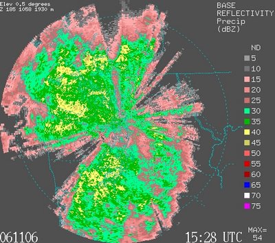
November 6, 2006 at 3:28 pm
Snohomish River, WA November 8, 2006
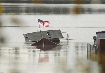
Photo from Seattletimes.com
It rained for 40 days and 40 nights! Well, alright it didn't rain that much, but I can imagine what it would be like if it had. We've had some record breaking rain these last couple days in Seattle. Between Last Thursday (11/2/06) and Tuesday (11/7/06) we got 7.57 inches of rain, which breaks the record for a 5-day period set in 1979 of 6.69 inches. Furthermore that is for the rain gage located at Sea-Tac International Airport, which historically gets less rain then anywhere else. This equates to about a once in a 100 years kind of storm.
Stampede Pass, which is located south of Snoqualmie Pass got 8 inches of rain in 24 hour period between Monday and Tuesday. Snoqualmie Pass got around 7 inches in the same 24-hour period. What does all this mean well take a look at the pictures.
Snoqualmie River, WA November 7, 2006

Photo from Seattletimes.com
Check out this article from the Seattle Times and look at the pictures from the last several days. It's pretty incredible. I posted some pictures that I got from their web-site, but it's only a few. You'll need copy and paste the link into your browser.
seattletimes.nwsource.com/html/localnews/2003365622_flood08m.html
Snoqualmie River Valley Near Carnation, WA November 7, 2006
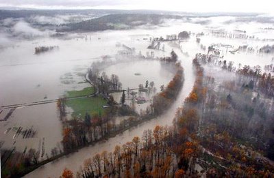
Photo from Seattle times
It's simply amazing to witness the power of water.
House going rafting down the Cowlitz River
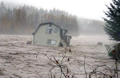
Photo from Seattletimes.com
The next picture is an actual road project that my firm is currently working on the design right now. Think there might be a drainage problem? Just for a reference the water is close 5' deep directly under the bridge.
Hardie Avenue, Renton, WA
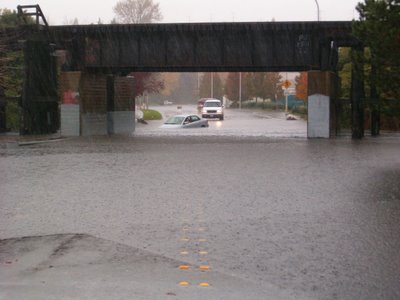
Photo by Derek Akesson
Skykomish River more than tripled it's flood stage and it was only one a of many river to reach flood levels. The Skykomish River, for those who don't know, is the local class III run close to Seattle that runs all year. It is also the main tributary for the Snohomish River, which has been in the news a lot lately.
Check out the graph below and the red horizontal line is the flood stage for the Skykomish.
Skykomish River River Stage
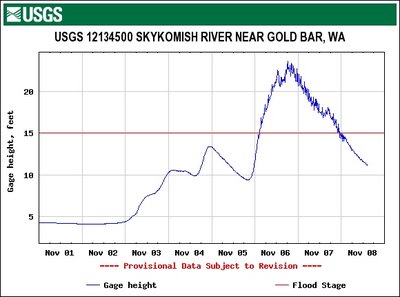
From USGS
If you're not a kayaker the next pictures won't mean much. This next picture is taken as if you're heading east on highway 2 and looking left going over the steel truss bridge just before the town of Index, WA. This is the confluence of the north and south forks of the Skykomish River. Normally you would see about 15-20 feet of river bank even during moderate winter flows.
Skykomish Confluence near Index, WA

Photo from professorpaddle.com
You can also check out more kayaking related flood pictures at the following link including some guy that tried to kayak the Sky and ended up swimming through boulder drop.
For pictures check out:
http://www.professorpaddle.com/mediaupdates.asp
For a description of the swim through boulder drop check out:
http://www.professorpaddle.com/forum/forum_posts.asp?TID=1531&PN=1
Pretty entertaining stuff for sure.
One last picture and graph. Here's a picture of Snoqualmie Falls taken on November 6 sometime in the afternoon. At about the same time as the Satellite photo shown at the top of this post. I also included the USGS real-time flow graph for the last week. When the picture was taken of the falls the river at exceded it's flood level.
Snoqualmie Falls

Photo from Seattletimes.com
USGS Flow Graph for week of Nov 1 through Nov 8, 2006
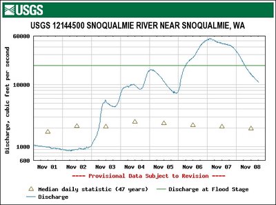
From USGS.gov
More trip reports from the summer to come in the next few weeks.

November 6, 2006 at 3:28 pm
Snohomish River, WA November 8, 2006

Photo from Seattletimes.com
It rained for 40 days and 40 nights! Well, alright it didn't rain that much, but I can imagine what it would be like if it had. We've had some record breaking rain these last couple days in Seattle. Between Last Thursday (11/2/06) and Tuesday (11/7/06) we got 7.57 inches of rain, which breaks the record for a 5-day period set in 1979 of 6.69 inches. Furthermore that is for the rain gage located at Sea-Tac International Airport, which historically gets less rain then anywhere else. This equates to about a once in a 100 years kind of storm.
Stampede Pass, which is located south of Snoqualmie Pass got 8 inches of rain in 24 hour period between Monday and Tuesday. Snoqualmie Pass got around 7 inches in the same 24-hour period. What does all this mean well take a look at the pictures.
Snoqualmie River, WA November 7, 2006
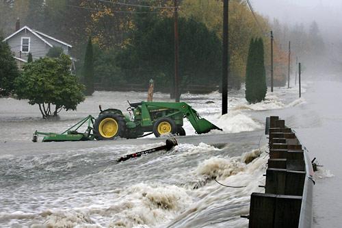
Photo from Seattletimes.com
Check out this article from the Seattle Times and look at the pictures from the last several days. It's pretty incredible. I posted some pictures that I got from their web-site, but it's only a few. You'll need copy and paste the link into your browser.
seattletimes.nwsource.com/html/localnews/2003365622_flood08m.html
Snoqualmie River Valley Near Carnation, WA November 7, 2006

Photo from Seattle times
It's simply amazing to witness the power of water.
House going rafting down the Cowlitz River

Photo from Seattletimes.com
The next picture is an actual road project that my firm is currently working on the design right now. Think there might be a drainage problem? Just for a reference the water is close 5' deep directly under the bridge.
Hardie Avenue, Renton, WA
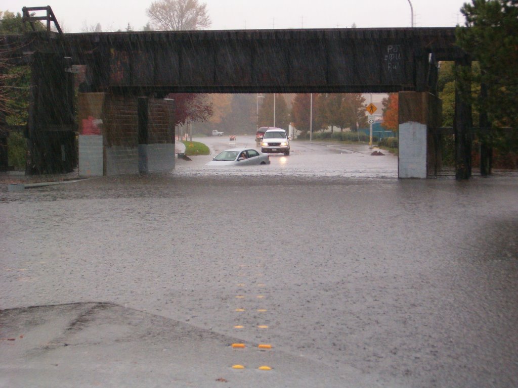
Photo by Derek Akesson
Skykomish River more than tripled it's flood stage and it was only one a of many river to reach flood levels. The Skykomish River, for those who don't know, is the local class III run close to Seattle that runs all year. It is also the main tributary for the Snohomish River, which has been in the news a lot lately.
Check out the graph below and the red horizontal line is the flood stage for the Skykomish.
Skykomish River River Stage

From USGS
If you're not a kayaker the next pictures won't mean much. This next picture is taken as if you're heading east on highway 2 and looking left going over the steel truss bridge just before the town of Index, WA. This is the confluence of the north and south forks of the Skykomish River. Normally you would see about 15-20 feet of river bank even during moderate winter flows.
Skykomish Confluence near Index, WA
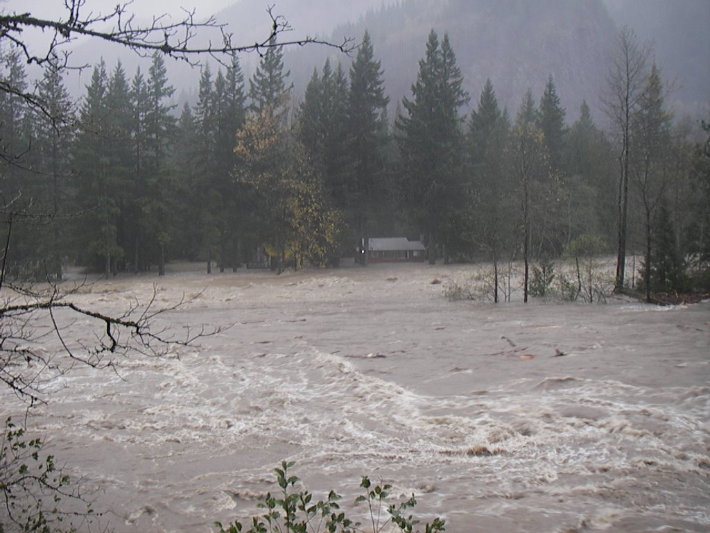
Photo from professorpaddle.com
You can also check out more kayaking related flood pictures at the following link including some guy that tried to kayak the Sky and ended up swimming through boulder drop.
For pictures check out:
http://www.professorpaddle.com/mediaupdates.asp
For a description of the swim through boulder drop check out:
http://www.professorpaddle.com/forum/forum_posts.asp?TID=1531&PN=1
Pretty entertaining stuff for sure.
One last picture and graph. Here's a picture of Snoqualmie Falls taken on November 6 sometime in the afternoon. At about the same time as the Satellite photo shown at the top of this post. I also included the USGS real-time flow graph for the last week. When the picture was taken of the falls the river at exceded it's flood level.
Snoqualmie Falls

Photo from Seattletimes.com
USGS Flow Graph for week of Nov 1 through Nov 8, 2006

From USGS.gov
More trip reports from the summer to come in the next few weeks.
![]()
Subscribe to Posts [Atom]
